@ mile 2189.2 all together on the Appalachian Trail by the way.. 0 miles LEFT TO GO!!!
 |
| This state crossing was the hardest... the sign is down a sheer, steep, long rock face (which of course we climbed down in the rain, because that is how our lives we destined to be lived on the trail at this point) which I had promptly fallen on my face and slid down no less than four times. Then for kicks the trail maintainers placed the sign in the middle of a freaken swamp... seriously it was the only swamp around for miles, I don't know how they managed this feat, but they did. I hope they were proud of themselves. Anyway, this final crossing was the most exciting! |
29 June 2015: 21 miles to Full Goose Shelter
- Of course it was raining, like usual, most of the day
- The trail just got HARD. I honestly think NH and ME were in competition to see which state could make the trail the suckiest for thru-hikers.
- Probably what NH and ME trail club maintainers say to each other when picking were to route the AT:
"Hey Tim lets put the trail over EVERY rock face we can find, no need to go through the nice un-rocky woods RIGHT NEXT TO the rock face."
"Great idea Jim!!! Hey look there is a swamp ON TOP of this rock face, lets route the trail there too!!! Then we can hide the wooden planks UNDER the mud so no matter what their shoes will get soaked... but we will leave one plank out so when a hiker steps they will be swallowed in mud up to their thigh."
"Oh, Tim! You are a genius!!!"
"Thanks Jim! Then for kicks, lets JUST STOP painting blazes for a while"
- We showed up at the shelter and it was crawling with SoBo thru-hikers. We tried to get information about the trail to come from them (since they had just hiked it) and all they had to say was "The suck never ends!!! The rocks never end!!!" Not what we wanted to hear... and also, not very helpful.
- ***the rocks and suck ended 40 miles later, they were just suffering from PTSD-due to having just completed the hardest 15 miles of the AT that day... or they were just morons
 |
| Of course one of the pluses of not being a fair-weather-hiker is we get to watch the rain clouds roll in and out from between the mountain peaks |
 |
| Or the sun breaking through a rain cloud as we beheld our first lake in Maine (I had one of my worst falls of the trail about a minute after this picture was taken, just to make sure I snapped back into reality) |
30 June: 15.5 miles to Frye Lean-to
- Hardest day of the entire trail, terrain wise
- Mahoosuc(k) Notch is filled with holes to break your leg in and abysses to drop your poor flipflops into
 |
| Breakfast before the Notch |
 |
| Times these giant boulders and scrambling through rocks by x200 and that is the Notch . It took us 2.5 hours to go a little over a mile... oh and then right after the Notch we got to climb up another fun rock face, just for kicks! |
1 July 2015: 23.3 miles to Bemis Mountain Lean-to
- This day was difficult as well due to a cold misty rain that fell ALL DAY, but with the perspective of the day before, it was not that bad
- For some reason (probably because of the amount of rock climbing we were still doing) we just couldn't get back to our typical hiking speed of 2.5 mph (which includes breaks, so roughly 2.8 mph).
- We had been lucky to get above 1.5 mph for the last two days
2 July 2015: 17.7 miles to The Farm House Hostel (Rangeley, ME)
- 2 miles after the shelter the trail magically got easier... too easy... we were back up to 2.7-3 mph... we anticipated some kind of cruel trick that was trying to lure us into a false sense of security
- We were meeting up with Thare (Poppin's uncle) that evening in Rangeley. We told him that we would be in the parking lot at 5pm (on account of how hard the past two days had been)... we got there at 1:30pm.
- No tricks, apparently the hardest part of the trail was now behind us for good
- Thare took us to resupply and out to dinner. It was a lovely evening at a cute little hostel that was under renovation.
 |
| The Farmhouse had a cute little pet pig |
3 July 2015: 8 miles to Redington Campsite
- Had a chill morning in Rangeley... where apparently spandex shorts are non-existent (we went to every outfitter in town looking for these things)
- Went over the Saddle back mountain range, some of the most impressive views since the Whites
 |
| Saddleback Mountain |
 |
| Saddleback Mountain 2nd peak |
 |
| The Horn (as in the horn of a saddle) |
 |
| A random privy we found on the trail... so of course Poppins had to use it, there was even a trail log in there... |
 |
| Top of Saddleback Mountain |
 |
| A typical camp set up for us in the woods |
4 July 2015: 24.2 miles to Barbara's house (Stratton, ME)
Trail Magic at it's finest: Poppins and I were stumbling down (because walking is too generous a term of how we descend rocky mountains) Sugarloaf Mountain when we happened upon a mother and daughter heading southbound. The mother asked if we were thru-hikers and what our plans were for the evening. Unfortunately for all parties involved I was in front so I was the one who had to do the communicating... which is usually Poppin's job... because, well, if you know me you understand why. (Apparently I have a "bad, black, aura" about me, although I was hoping I would have replaced the "bad aura" with just a "bad smell" and become a friendlier person on the trail.)
Anyway, the nice woman, Barbara, was able to comprehend from my derpy, broken, confused, answers that we were headed to Stratton to resupply and really had NO CLUE where we were going to stay in town. Barbara explained that she had read an article in a magazine about "trail magic" for thru-hikers and she wanted to do some for us. Then she offered to take us back to her home for the evening... Now, usually the "trail magic" we had experienced on the trail had been simple coolers of drinks, candy, or the random individual making hot chocolate or eggs for the passing thru-hikers. Don't get me wrong, we appreciated EVERY BIT of trail magic we experienced on the trail, no matter how small... but we had heard tales of this SUPER-DUPER RARE (because the simple trail magic is already rare enough when we are this far ahead of the NoBo bubble), EXTREME trail magic of people welcoming smelly hikers into their homes, but had never expected to encounter it in our trek. I just sort of stared for a little while and fumbled for words to this generous offer. Barbara and I exchanged phone numbers and agreed to meet at the next parking lot (about 10 miles away) at 5pm. Barbara and Emily then headed on their way. Poppins walked up and asked what "that" was all about, because it is so rare for me to stop and talk for so long with southbounders; Poppins had perched on a rock higher up on the trail and talked to Emily while I was talking to Barbara.
I explained that we had just been invited to someone's home for the evening... and we had to be at the road by 5pm (we were originally planning on being at the road by 6:30pm). :) We took off and zoomed down the mountain, up and over another, forded a river, then down another mountain, to the road and were only 15 minutes behind schedule. Barbara picked us up and shuttled us into town for a quick resupply then back to their beautiful home near Sugarloaf Mountain (Emily and she had been literally hiking back home when we met them on the mountain).
The evening was lovely. We regaled our hosts with our silly, odd, smelly thru-hiker stories and listened to all the adventures and sports Barbara, Emily, and Dick (Barbara's husband) had been involved in over the years. Quite the active family. Emily was even headed off to a backwoods leadership program in less than a week. We gave her what advice we could on backpacks that were comfortable for females and what features we had noticed were helpful to have for the longer treks through the woods.
During dinner we got a full history lesson on the dams in the area (which Barbara is very passionate about and helping to resolve the problems in the ecosystem the dams have caused over the decades), mountains (especially the Bigalow mountain range, which we were going to be climbing the next day), and the surrounding area. I must say, all the added information about the region we were hiking through added something to our experience in the area. The landscape and terrain turned from "oh just another mountain to climb" to a living history we could see and connect with. An unexpected, yet appreciated bonus to the trail magic experience... and during dinner no one commented on how we ate like little ravenous wolves. I guess the article on trail magic Barbra had read mentioned that fact about thru-hikers. Perfect.
After breakfast the next morning Barbara took us back to the trail and we continued on our way, promising to keep them posted on our trek. The whole 12 hour experience was amazingly generous and will probably be one of the things that sticks with me the most from the whole trail. Even in the days that followed when we were talking about Katahdin we would mention how "cousin Emily" was able to climb it when she was 8yrs. old so we really shouldn't worry. We hope to meet up with Barbra and Dick on our way back through Maine before we head home for VA.
 |
| A mountain hen... probably the stupidest birds on earth. This one kept running away from us and then stopping to peck the mud, finally it flew up into the tree 1 foot above our heads. I could have slapped it down with my hand. At least we wouldn't have starved if we got lost in the Maine woods, although I would have had to break my vegetarianism... although this bird is so stupid it might count as a plant... |
 |
| The AT use to end here... we could have been done |
 |
| Lunch spot |
5 July 2015: 23 miles to West Carry Pond Lean-to
 |
| !!!! 189.2 to go!!! |
 |
| Feet at 2000 miles |
 |
| Bigalow |
6 July 2015: 28.7 miles to Bald Mountain Brook Lean-to
- Kanabec River crossing is an interesting part of the Appalachian Trail tradition. The Kanabec River is wide, deep (compared to other streams and rivers we have to ford), and there is a dam upstream where throughout the day the slews gates are opened and the water level can rise very quickly, to dangerous levels. It took a few unfortunate drownings of hikers trying to ford the swollen river to make the Appalachian Trail Conservancy re-think the "no bridges in Maine" policy (which is a complete and udder lie by the way, we saw bridges on other trails AND on some parts of the AT, but maintaining such a big bridge would be difficult).
- The solution to the potential drowning factor was for a local outfitter to offer a ferry service across the river. The ferry was a one toothed old man in a canoe that could take two hikers across at a time. Kind of novel honestly. There is even a white blaze painted in the bottom of the canoe so the ferry counts as the OFFICIAL way to cross the river, to keep the purest thru-hiker (a hiker that has to pass ALL the white blazes no matter how dangerous) drownings to a minimum.
- Poppins and I are "purest" to a point. We believe in passing all the white blazes if possible, walking EVERY part of the trail, and see yellow-blazing (cheating) as the worst of all thru-hiker sins. But we WILL take a high water blue blaze trail if a river crossing looks dangerous; we had to take an alternative path only once and that was in New York after 3 days of heavy rain. We could see the blazes under the murky brown water. No regrets. Our lives are worth more than the paint on a rock... that is under water in a fast moving river.
 |
| Thru-hikers waiting to cross |
 |
| Poppins paddling |
 |
| Stoat not paddling |
7 July 2015: 22 miles to the Lakehouse Hostel (Monson, ME)
- Last trail town for us on the AT, a bitter sweet feeling
- Monson was small and expensive, fortunately we had sent ourselves a full supply box which turned out to save us A TON of money in the end
 |
| The bugs were pretty bad apperently |
 |
| Muffin Man (a SoBo) making us muffins over the fire!!! So cool!!! but too much effort so we will never do it ourselves!!! |
 |
| Crossing yet another stream |
 |
| Poppins new look |
 |
| Relaxing at the Lakehouse Hostel in Monson, ME before hitting the 100 mile wilderness |
8 July 2015: 26 miles (in the 100 Mile Wilderness) to Chairback Gap Lean-to
- ... the 100 Mile Wilderness is well known for suggesting that hikers take 10 days worth of food in with them... Poppins and I took 2 days worth of food in with us and had a resupply drop with 2 more days left for us half way through... it was more than enough. I really don't see why everyone freaks out about this.
- Although I can see how it would be difficult for southbounders who do not have their trail legs yet. We did sympathies with them and assured them the trail would get better and they would get stronger.
- We did meet tons of southbounders unfortunately who said they were getting off the trail in Monson, which was very sad because their adventure had barely begun.
 |
| This is the sign at the start of the 100 Mile Wilderness that basically says "bring 10 days of food or you will die" ... how much food do Poppins and I have at this point? 2 days, 2 days worth of food... we are overconfident about out abilities... but it worked |
 |
| Poppins crossing a river |
 |
| Poppins derping out crossing a river |
 |
| Stoat having already crossed the river making fun of Poppins crossing the river |
 |
| ... I got in the habit of packing out doughnuts at the end of the trip... I was quite satisfied with my decision |
 |
| 100 Mile "Wilderness" my stoat-tail!!! 3 hours in we hit a road with a car pulling in... throughout the rest of the wilderness we saw many people in many cars (probably 15) |
 |
| A rare flower that a sign at the start of the bog warned me about not stepping on. If it is so rare why is the trail even going through the bog. I wanted to step on it out of spite but didn't ... because I'm an adult and shouldn't retaliate to stupidity passive aggressively... but the temptation was very real |
9 July 2015: 32.5 miles (in the 100 Mile Wilderness) to a stealth campsite
- ...heard it was suppose to rain on our projected finish date (12 July)... so we decided to "push"
 |
| Lunch spot |
 |
| Stoat attempting to use "panorama" on her camera because she JUST figured out how to change the settings |
 |
| We sent ourselves a resupply bucket in the 100 mile wilderness. The Lakehouse offered a 5 gallon paint bucket (that we filled before leaving) supply drop halfway through for $25, which Poppins and I could share. So we sent ourselves some self-imposed trail magic. Some thru-hikers see these resupply drops as "cheating" we saw it as "not being stupid in a "wilderness" that is filled with roads" |
10 July 2015: 37.4 miles (in the 100 Mile Wilderness) to Hurd Brook Lean-to
- Bluetoes!!!- Bluetoes is the guy who had been "chasing" us since southern VA and finally caught us in northern Vermont. He thought he had passed us but since we did two crazy mile days in the 100 mile wilderness WE CAUGHT HIM back!!! He is a great guy and was a good sport about it and we were excited to see him again.
- It was funny. Poppins walked up to the shelter at 9pm (which is a little rude of us to walk up so late... but it was dark and raining) and Bluetoes just kind of stared, then I walked up next to Poppins and he exclaimed "IS that Stoat and Poppins!?!" his brain couldn't make the connection about who was stumbling up in the dark until he saw that it was two females... and Poppins and I were the only female team hiking the AT this far north apparently. Seriously, the last double female team we had seen/heard about was Maps and Moxie back in NC... and they were much older than us. We were a rarity .
 |
| The last lake in the 100 Mile Wilderness |
11 July 2015: 18.6 miles to the top of Mt. Katahdin!!! (then a total of 23.8 miles back down to the ranger station to get a hitch back to Millinocket, ME)
- We hiked 15 miles before starting up Mt. Katahdin... and somehow managed to ford 2 deep streams so my shoes were sufficiently soaked for our final ascent . I couldn't even complain to Poppins about wet shoes because she used her crazy long legs to rock hop and her socks stayed bone dry.
- Katahdin took us 5 hours to climb, it was the most rock scrambling we had to do the entire trail. We were VERY excited however so it felt like we floated up the mountain... and the ranger station at the bottom offers thru-hikers daypacks so we were rid of our 25+ packs... so that might have contributed to the "floating" factor
- We got to summit with Bluetoes!!
- At the top of Katahdin there were about 20 daywalkers, when they heard we had just completed the entire AT the three of us received a round of applause. Magical.
- Suddenly, 20 minutes later, all the daywalkers left and it was just Poppins, Bluetoes, and I. We all just took a few seconds to watch the view at the end of our adventure on top of the world.
 |
| So close to the top, yet so far... |
 |
| Our FINAL Trail Log entry |
 |
| Number 37 and 38 NoBo finishers for the year!!! For perspective we were #132 and 133 at Harper's Ferry and #564 and 565 for the Georgia start back in March. We are fast :) |
 |
| View on the climb up Mt. Katahdin |
 |
| Probably some of the most epic views of the entire trail. Amazing... but I had to walk 2189.2 miles for these views so they better be worth it!!!... I feel sorry for the SoBo's Mt. Springer, GA is NOT impressive (we almost missed the Mt. Springer summit because it was so unimpressive) |
 |
| View mid-rock scramble |
 |
| Poppins wanted a picture of her pulling herself straight up because it was such an epic rock scramble... but it turned out to be just a butt shot |
 |
| Stoat, Bluetoes, and Poppins |
 |
| Our official (AKA the best we took) Mt Katahdin Summit photo we will be showing people the rest of our lives |
 |
| Ok this is silly, but fun. This cairn is 13 feet tall because the actual summit of Katahdin is actually missing the "mile above sea level" mark by 13 feet... so now Mt. Katahdin is exactly one mile above sea level... |
 |
| A picture without Poppins incase I want to be an a$$ and pretend she was never there... or need a picture to use on an online dating site... standards... |
 |
| Another individual picture. No really I'm just worried about my future children getting confused about which female is mommy and which is Auntie Poppins because we are going to look so different in 20 years and children are stupid. Therefore I wanted to take a few pictures by myself. |
 |
| Epic |
 |
| Epic again because I couldn't pick which to use |
 |
| ...now the issue with finishing on the top of Mt. Katahdin is you then have to climb back down... and then somehow find a ride back to society. Bluetoes and Poppins were still derping around collecting their stuff at the ranger station when I saw a car approaching... I'm not the best at catching rides on account I glare at everyone and everything naturally (not my fault) but I must have been so elated from finally finishing an amazing adventure that the joy showed through on it's own. Or they were just really nice people... anyway, these are our last trail angels of the trip, they took us all the way back to Millinoket, ME |
 |
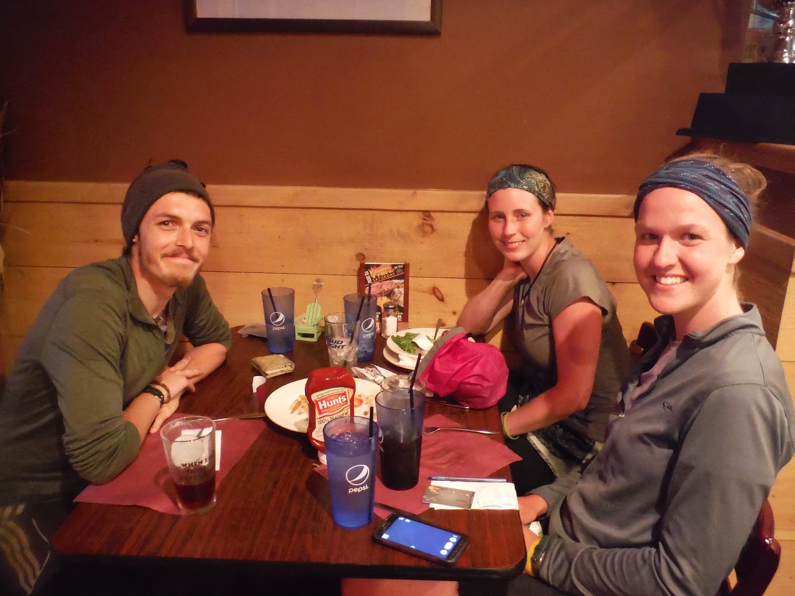
| Victory dinner with Bluetoes and Poppins!!! |
Life After the Trail: 12-15 July 2015
Poppins and I had 5 days to kill before our parents showed up to rescue us from the woods... so what do we do? We rented a car and drove back to Rangeley, ME to meet up with our favorite people from the trail we never got to say a proper goodbye to... because we never expected to hike the trail that fast. Also, we were kind of in shell shock from getting dumped back into society and we didn't like it, we basically ran back to the AT... to continue living like hobos for a few days
 |
| Not functioning well in society... we retreat to what resembles a shelter in Rangeley, ME |
 |
| Bought some charcoal and boiled some potatoes and fried some eggs, then tuna and brown mustard on my half... because Poppins is a picky eater |
 |
| Got to see the AK twins one last time!!! |
 |
| We love them, haven't seen them since Pine Field Shelter in VA |
 |
| Link and Folklore |
 |
| Link playing his ocarina for us one last time |
 |
| Met up with Sweet Blood and camped with her on the AT one night. She even took a zero day in Rangeley to hang out and we drug her everywhere with us! |


